
Bridge and Highway Scanning Using Multi-Antenna Systems
United Scanning have been leading the way for their clients in the innovative use of Ground Penetrating Radar (GPR) in WA. Now, United Scanning is proud to be able to present the next wave in Ground Penetrating Radar data collection. The United Scanning system is a dedicated, vehicle towed ground penetrating radar solution able to provide swift and efficient 3D surveying and mapping of concrete, asphalt and other common hard surfaces. It provides real-time on-site data acquisition and guidance software to produce high quality 3D tomography datasets.
The United Scanning solution is the ideal solution for surveying and mapping large scale structures like bridges, highways, decks and jetties, large areas of underground services and features, detecting underground structures, pipes and tanks or identifying and mapping cavities.
One of the key challenges faced in planning large scale surveying and mapping projects is that they can often involve significant disruption in and around the structures and the areas being mapped. Large scale and long term traffic management may be needed and significant safety infrastructure may need to be put in place, like barriers, flagging and detours. The interference to the normal use of the structure or space can undermine the project utility and make it more challenging to justify the value and necessity of the scanning exercise. The United Scanning system has been constructed with the goal of resolving this very problem.
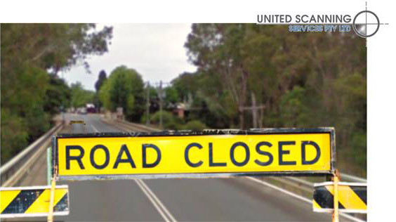
Figure 1: A key challenge in bridge and highway scanning
The United Scanning system is a fully configurable array of antennas, allowing for a selection of up to 40 antennas depending on the width of path that the project demands must be scanned in one pass. The higher the number of antennas that can be placed in parallel, the wider the area that can be scanned in one pass. With this solution a scan width of up to 1.84m being achievable.
This modularity allows the system to be reconfigured dependent upon the needs of the project. For areas with challenging accessibility and narrow or enclosed areas the solution can be restructured and if necessary put into a cart that can be pushed by a technician rather than requiring a vehicle in the space.
The width of the scannable area is not the only innovation that addresses the problem of disruption caused by scanning. This solution is a vehicle towed system. This has two key impacts on scanning projects.

Figure 2: The vehicle towed bridge and highway scanning solution
Firstly, due to the ability of the system to take as many as 87 scans per second per antenna and the fact that it is towed behind a vehicle, our system can cover a very large area in a shorter period of time. The maximum speed at which the scanner can be towed and still acquire viable data is 15km/hour. This reduces the period of time that disruption occurs and in some cases, will completely remove the need for traffic or pedestrian management around the scanning.
Secondly, because the United Scanning technicians are inside the cab of the vehicle towing the GPR data acquisition system, the risks of injury to our technicians are significantly reduced. This has an impact on the need for extensive traffic management and safety arrangements and consequently the costs of the data acquisition.
Another innovation is the use of antennas at several frequencies. Antennas with a central frequencies of both 200Mhz and 600Mhz are simultaneously in use in this solution. As a rule of thumb, the higher the frequency chosen, the lower the depth the signal is able to penetrate to, but the higher the resolution of the imagery acquired. Because the frequency used has this direct impact on both the penetration depth and the resolution, United Scanning is providing a solution that provides a happy unification of both penetration depth and resolution.
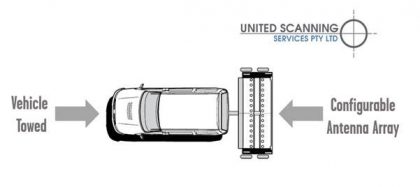
Figure 3: The United Scanning GPR bridge and deck scanning solution
These antennas are all dual polarised. This is an important innovation. A limitation of standard single polarisation antennas is that they are very good at detecting features that run perpendicular to the path of travel, but features that run parallel can be much harder to detect. This weakness is mitigated with the use of dual polarised antennas. This again has a direct effect on the amount of disruption and cost of the project. Where in the past the same area of bridge decking or highway may have required scanning in two directions at 90 degrees to each other in order to capture all the features under the surface, the use of dual polarised antennas means that a single pass will sufficient.
The software solution for processing the data produced by this system is also worthy of comment. It is a highly capable tool that allows for processing of the acquired data in real time, overlaying tomographic data on a cartographic background like a Google Map or KML. This allows for useful information to be created that can be provided to clients onsite during the scan and the swift identification of areas that need further attention.
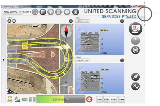
Figure 4: GPR Data on a cartographic background in real time
The software can automatically transfer to CAD and GIS formats such features as pipes, cables and buried objects allowing United Scanning to create and deliver a complete subsurface GIS based digital map in a very short period of time.
United Scanning are extremely pleased to be the first to be able to provide an offering of this quality and technical superiority to our clients. We invite you call us today and discuss how we can help meet your projects requirements.
Key Benefits:
- Highly efficient solution reduces project costs and time
- Speed of scanning reduces disruption
- Highly resolution and accuracy
- Dual polarisation reduces need for rescanning
- Modular structure allows solution to meet the most demanding of requirements
- Powerful software provides real time results
Software solutions allows for export of GPR data to CAD or GIS systems