
Using Ground Penetrating Radar to Assess Soil Moisture
United Scanning are a leader in the provision of Ground Penetrating Radar service location and concrete scanning services in Western Australia. United Scanning have worked with clients on major construction projects, renovation works, remediation jobs and insurance investigations and are proud of their contribution to their clients successes.
United Scanning use Ground Penetrating Radar to answer a broad variety of questions for clients. Questions about the location of specific services, the defects or services present in concrete, the depth of bedrock and the ideal point at which to penetrate a structure are some examples. United Scanning have even been asked to locate the paths of the roots of significant trees near work sites using Ground Penetrating Radar.
Answering most of these questions revolves around providing the dimensions and locations of specific things within a substance. How deep is this slab? Where is the reinforcement located? How much cover is over the post tensioned cables? How deep is the trench through which the services run?
However, Ground Penetrating Radar can be used to answer a much broader variety of questions. One question whose answer has an impact on a broad variety of industries and project types is, “How much moisture is in this soil?” Analysis of soil moisture has applicability to agriculture, earth sciences, insurance not to mention civil engineering and construction.
A recent research paper (Benedetto et al.) out of two universities in Italy examined the use of Ground Penetrating Radar to investigate soil moisture levels for the purpose of preventing damage and allowing for effective moisture management in the construction of roads and pavements. Variations in moisture content in the soil across the space that a road or pavement is constructed can have significant effect upon the bearing, durability and quality of the surface being laid. The purpose of this research was to provide a faster and more effective way of assessing moisture variation, and to use GPR to achieve this.
The researchers used a RIS MF Ground Penetrating Radar from IDS to perform the required scanning. A dual antenna system was used, scanning at 600Mhz and 1600Mhz. This system is very similar to the dual frequency GSSI trolley mounted scanners used by United Scanning to perform service locating for clients across the state.
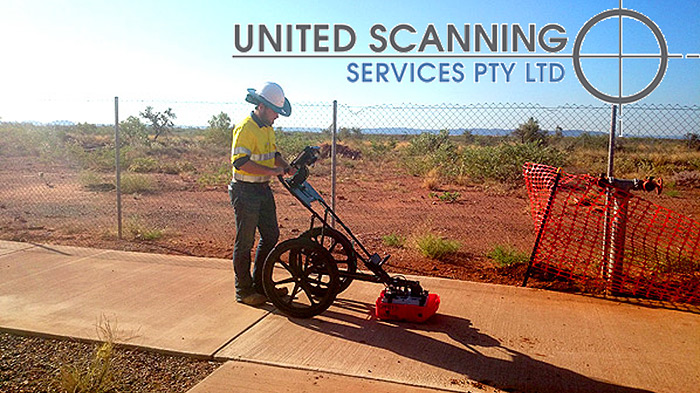
Figure 1: Dual frequency scanners in use by United Scanning
IThe team scanned an area of 16m2 with each pass of the scanner being 1m from the previous pass, resulting in Ground Penetrating Radar data being acquired along 34 sixteen meter passes, as pictured below (yellow lines). The team moved at around 3km/h during this scan and took a total 21,300 data points. In order to verify the quality and validity of the data they were collecting using the radar system, they also planted 8 soil moisture sensors across the area being scanned to provide an independent source of data (red number circles).
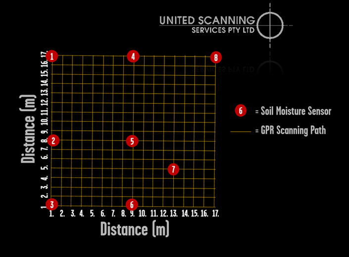
Figure 2: Plan of Soil Moisture scan
Ground Penetrating Radar works because different materials are more or less capable of transmitting radar. This capability is called the dielectric permittivity of the material. Water and soil have very different dielectric permittivity’s. Permittivity is measured in farads per meter (F/m) with dry soil being around 4 F/m and water being 81 F/m. This means that radar is very sensitive to moisture and high amplitude reflections will likely be seen at levels where high moisture contents are found. If the dielectric permittivity of the soil can be considered to remain constant due to relatively uniform soil type, it is possible to see differences in moisture levels by comparing the amplitude of the signal returned by different regions within the scanned area.
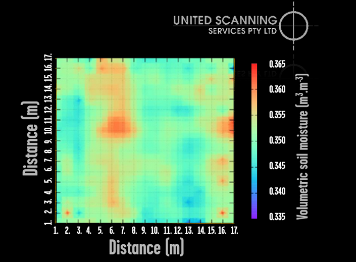
Figure 3: Mapping moisture content in soil using GPR
The researchers found a high degree of correlation between the values derived from the specialised soil moisture sensors and the data acquired by utilising Ground Penetrating Radar. Furthermore, using the soil moisture sensors data as a guide they were able to assess the attenuation of the signal that occurred in different areas of the scan and use this to produce a detailed map of the moisture content in the soil.
Their research concludes that Ground Penetrating Radar is an effective tool for measuring soil moisture levels and provides the information in a much faster and more detailed way than many other approaches.
References:
Benedetto, Andrea et al. ‘Soil Moisture Mapping Using GPR For Pavement Applications’. 2013 7th International Workshop on Advanced Ground Penetrating Radar (2013): n. pag. Web. 9 Dec. 2015.